Stage 16 - The Ridgeway - Mongewell to Princes Risborough - June 9th 2025
- John Tippetts

- May 7
- 8 min read
Updated: 2 days ago
Official Stage Statistics
Route distance – 19.64 miles
Total ascent – 1786 feet
Total descent – 1646 feet
Highest point – 706 feet

Logistics
Drive to Goldsmith's Lane Wallingford Car Park OX10 0DN - £6 for day - Pay by Phone – location 810589
Walk to Market Place & catch X40 bus to Mongewell Turn
Walk to Princes Risborough Station
Catch train to Oxford
Catch train to Didcot Parkway
Catch X40 bus to Wallingford
Pick up car & drive home
My Walk
This was going to be my longest walk along The Ridgeway and the 2nd longest overall along the Great Chalk Way. So why on earth did I walk it twice – firstly in May and then again in September? It was for the same old reason; in May it was a pretty overcast day but in September it was a glorious day. This was to be the 3rd and last of my repeated walks. By the time I reached Princes Risborough I would be more or less at the halfway point of the Great Chalk Way. This would be the first stage that I would do as a day trip from home.
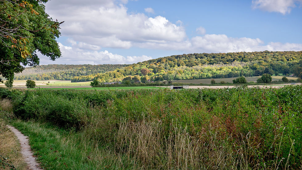
Starting from Mongewell (which is really part of Wallingford), the first few miles would be following the Grim’s Ditch (AKA Grim’s Dyke) as far as Nuffield. There are a number of Grim’s Ditches in England, mainly in the South East. They are prehistoric bank and ditch linear earthworks. The purpose of them remains a mystery but as they are too small for military use, they may have served to demarcate territory. This Grim’s Ditch stretches for about 5 miles but The Ridgeway follows it for about 3½ miles. I’d come across another Grim’s Ditch on the final stage of The Ridgeway.
At Nuffield the trail would turn left and cross numerous fairways of Huntercombe Golf Club. After crossing a couple of large fields and walking through some woodland, the path would climb to its highest point near Swyncombe before dropping back down. For the next 7 or so miles beyond Swyncombe the trail would level out and I’d be walking along a virtually straight path, which at times was completely open with great 360° views. At other times it would also pass through woodland and least appealing, the path would have trees and bushes on either side giving limited views of the landscape. For this 7 miles the trail would intersect numerous roads and tracks, leading to towns and villages like Watlington and Chinnor.
Beyond Chinnor, the path would bear right and climb up to the top of Lodge Hill, before a final 2½ mile descent into Princes Risborough.
My day began with an early morning 80 mile drive from home to Wallingford. I parked my car and caught the X40 bus from the Market Place to the ‘Mongewell Turn’ stop - 100 yards from The Ridgeway. At first the path was narrow with loads of trees and hedges on both sides but also with some breaks to allow some nice views of the landscape. After crossing a single track road, the climbing began in earnest up Grim’s Ditch along one of its banks. The ditch itself was pretty overgrown with vegetation and fallen tree branches, making it difficult to fully appreciate it. For this reason, I’m adding a photo from when I first walked The Ridgeway in February 2023. This really highlights the ditch and supports the theory that maybe it was for demarcation purposes as it would certainly be useless to keep marauders at bay!


At the top of the slope, the path turned left and very soon I emerged by the church in the village of Nuffield. The fingerpost directing you onto the golf course was partially hidden by vegetation so I walked past it when I did this walk in May. I managed to find a way to get back on track but this did involve walking along a busy road. You’d have thought when I did the walk again in September that I’d be more careful not to miss the sign – but I walked straight past again! This time however I quickly realised my error and backtracked until I finally saw the sign. After walking over a number of fairways I emerged at The Maker Space – a modern craft venue, shop, café and community space in a former 17th century pub building. I didn’t really fancy a coffee at this time but it’s good to know that the place is here.


After crossing the busy main road, the path crossed 2 very large fields before reaching a side entrance gate to the Ewelme Park Estate. From what I’ve read, the estate covers over 600 acres and the main house built in 1913 has 8 bedrooms and is Grade II listed. I believe the estate is owned by Mr Jaisal Singh. He operates his polo team from the equestrian facilities on the site – the Sujan Indian Tigers.


Continuing past Ewelme Park, the path descended quite steeply through woodland down to Swyncombe. There had been a considerable amount of tree clearance between my walks in May and September, resulting in some really nice views.


St Botolph’s Church in Swyncombe is well known for its snowdrops and ‘Snowdrop Teas’ each year. My Ridgeway walk past the church in 2023 fortunately coincided with one of the Snowdrop Tea days and I happily stopped to avail myself!


Beyond Swyncombe the path climbed steeply to the highest point of the walk, before descending through woodland just as steeply with views of the imposing Britwell House in the distance.


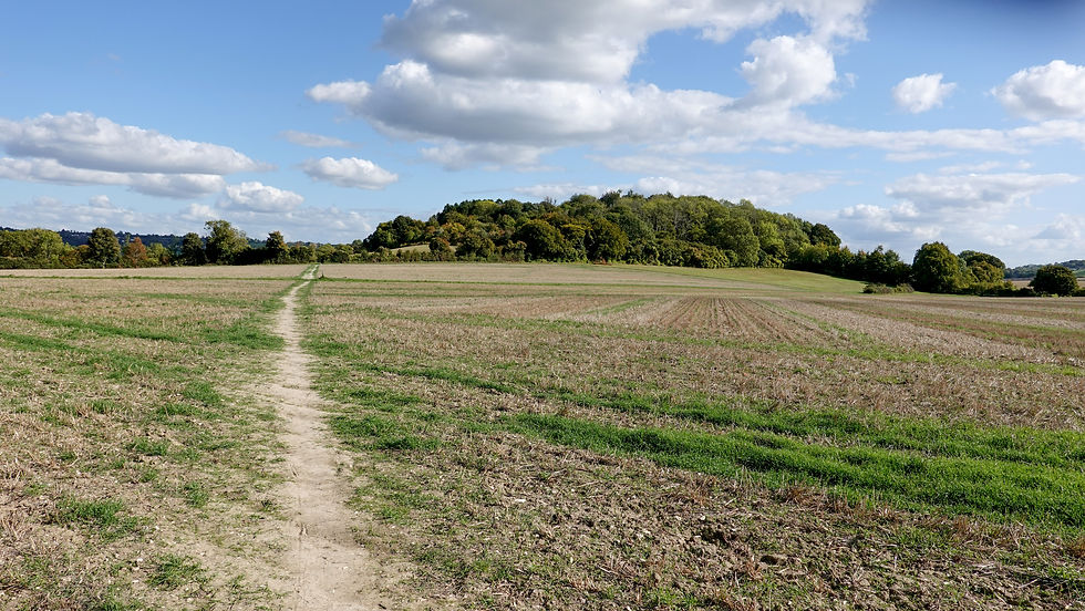
At the bottom of the hill at Britwell Salome the path took a definite 90° turn to the right, marking the start of about 7 miles of flat and virtually straight walking along a restricted byway known as the Lower Icknield Way.
The whole 7 miles were easy on the feet and as a stand-alone walk it was really pleasant. All the way along to the right of the path was the top of the ridge at about 800 feet, whereas The Ridgeway path hovered between about 450 and 500 feet. The Upper Icknield Way runs parallel to the Lower Icknield Way as a tarmac road along the top of the ridge. This is a good illustration of how trails such as The Ridgeway are forced to take the practical route at times (i.e. avoid the road) rather than the ridgetop route that would have been expected for a trail called The Ridgeway! On the left hand side of the path it was mainly farmland with great views beyond but as is often the case, the trees and hedges on both sides of the path obscured the views at times.


About halfway between Watlington & Chinnor the path passed underneath the busy and noisy M40 through its own concrete tunnel. Either side of the M40 and up to the right was Aston Rowant Nature Reserve, a 400 acre nature reserve at the top of the ridge that looks down on the motorway. Very soon after the tunnel the path crossed the A40, now considerably quieter since the M40 was built. It was here that I saw the first mention of the Icknield Way on fingerposts and this confused me a little but more of that on my dedicated page for the Icknield Way section.


At Chinnor, the path passed by former chalk quarries, although from the ground it wasn’t too easy to see all of them. The quarries were on the site of what started life in 1906 as The Chinnor Lime Company, a small company creating lime. Over the next 90+ years the site expanded to over 200 acres, was eventually taken over by Rugby Cement and became 1 of just 6 major cement production plants in the UK. Production ended in 2000 and the buildings were demolished in 2007/8 after the land was acquired by Taylor Wimpey. Today, the land & quarries on the Chinnor village side of The Ridgeway have been redeveloped and landscaped as a housing estate known as Old Kiln Lakes as well as recreational areas. One of the original lime kilns is now Grade II listed and can be seen in the housing estate near the playground. On the other side of the path, the large, extremely deep quarry has been filled with water and is strictly off limits to the public.

Beyond the old Chinnor chalk quarries, at Hempton Wainhill I said goodbye to Oxfordshire and hello to Buckinghamshire, as the path veered off to the right and climbed up through woods to emerge onto sheep grazing fields, about 1 mile from the village of Bledlow Ridge. This was a bit of a ‘Wow’ moment because for quite a bit of of today’s walk up to this point I’d felt relatively hemmed in compared to this.


Now in the open I could see Princes Risborough in the distance but rather than making a beeline for the town, The Ridgeway took a more circular route via a short but steep climb to the top of Lodge Hill. It has to be said that the views from the hilltop were worth the climb. Before carrying on I checked the times of trains to Oxford from Princes Risborough. It was 3 o’clock and the next train was at 15:50. I’d have to wait another hour if I missed this one so I decided to get a wriggle on.


From the top of Lodge Hill, the final 2 and a bit miles to the railway station were thankfully pretty much downhill all the way. The Ridgeway passed alongside the golf course, crossed a couple of railway lines and a large field before taking to residential streets in Princes Risborough. I reached the station at 15:40 giving me 10 minutes to cool down a little before my train to Oxford arrived.


Back in Oxford, I changed trains for Didcot Parkway, got the X40 bus back to Wallingford, picked up my car and drove home. A long but really successful day and I was now halfway along the Great Chalk Way!

The final stage of The Ridgeway would be Princes Risborough to Ivinghoe Beacon. My sister, who is fortunate enough to live within a couple of miles of The Ridgeway, had said from the outset that she’d like to do a Ridgeway Walk with me. I’ve done so many Chilterns walks with her in the past, including the Rennie Grove Hospice Chilterns 3 Peaks Challenge 3 times. The 3 Peaks challenge takes the route of this final stage, so I knew we’d be able to do this brilliant walk.
The problem was trying to find a suitable day when we would both be free as she is unfortunate enough to still have to work! In the end it would be 8 weeks before we’d set off from Princes Risborough. Whilst I could have started along the Icknield Way whilst waiting for her, I really didn’t want to do walks out of turn, so instead, to keep myself occupied I completed the Thames Path for the 6th time!


Comments